Graeme Collett et al.
Friday 23.08.19 Session 6 Georgie Kerby, Graeme Collett and Dr Ross Ramsay session on “Hawaiki revealed: Identification of Ancestral Homeland for an Early Polynesian Seafarer group to Southern New Zealand based on Petrology of their artefacts”
Hawaiki Revealed: The Identification of the Ancestral Homeland for an Early Polynesian Seafarer Group to Southern New Zealand based on the Petrology of their Artefacts
Ross Ramsay, Georgia Kerby and Graeme Collett
This triptych of presentations by a closely related group of researchers intricately argues a specific – and controversial – location of Hawaiki. Georgia Kerby is an archaeologist, recently curator of Kiwi North, now in commercial work. Graeme Collett is a lifelong collector, museum worker and student of precolonial material culture. Ross Ramsay is the geologist who located the source of a particular group of artefacts.
The Historical Discovery and Archaeological Context of Three Scoria Blocks from Māori Occupation Sites, Southern New Zealand - Essay
Collett G. S. Private researcher, Dunedin <collettgs@outlook.co.nz>, Ramsay W. R. H. Private researcher, Kerikeri [corresponding author] <wrhramsay@hotmail.com>, Ramsay, E. G. Whangarei Art Museum <egramsay@hotmail.co.nz>, Kerby G. Kiwi North, Whangarei <georgiakerby@gmail.com>
Graeme Collett and his associates tell a detective story. Collett assembled a team of a geologist, an archaeologist and a museum curator to solve the puzzle of a pair of volcanic scoria blocks left to him by pioneer archaeologist Les Lockerbie. A founding member of the NZAA, one-time president, advance worker in stratigraphic archaeology and in carbon dating, Lockerbie died in 1996 with a problem on his mind, which he left to Collett, his close friend and colleague of nearly forty years.
Two New Zealand sites had yielded two small blocks of gas-bubbled volcanic rock, and Lockerbie was convinced, just from the look of them, that they must be of foreign origin. A quarter of a century after Lockerbie’s death, modern isotope geochemistry confirmed that hunch. The story is told in the Wananga presentation, and in this paper.
Key Words:
scoria blocks, archaeology, archaic Māori, H. D. Skinner, L. Lockerbie, Catlins, Southland, East Polynesia
This manuscript is dedicated to the memory of Les Lockerbie and Russell J. Beck
Abstract:
The history of discovery, archaeology, and stratigraphic setting of three shaped, fresh, scoria blocks from three prehistoric archaeological sites in southern New Zealand are presented. Their discovery, commencing in 1939 with the Kings Rock block on the Catlins coast, was followed by the finding of a similar block nearby at Tautuku in 1963. In 1975 a further block was found on Rakiura (Stewart Island). Subsequent archaeological investigations at these sites were variously carried out by Les Lockerbie and David Teviotdale. It is argued that all three blocks are integral with the early stratigraphy of each occupation site. Fresh basaltic scoria is not found in Southland and Otago and hence each block had to have been imported from outside these locales. The scientific analysis, source locality for these blocks, and ensuing implications will be presented in a subsequent publication.
Introduction:
Commencing with an excavation at Kings Rock on the Catlins coast (South Otago) in 1937, a shaped scoria block was excavated. This discovery was followed by two further discoveries of shaped blocks from southern New Zealand. The second was recovered from Tautuku (Catlins coast) in 1963 and the most recent discovery was from the Old Neck, Rakiura (Stewart Island) in 1975.
This contribution documents the discovery of each of these blocks and provides an account of their archaeological context. The importance of these shaped artefacts is that fresh basaltic scoria is not found in the Catlins (south Otago), Southland, or on Rakiura, therefore the implication is that all three blocks have been shaped from material exotic to southern New Zealand. To our knowledge no other shaped scoria block has been found associated with Māori archaeological sites in New Zealand. This paper concludes with the Kenneth Emory expedition to Mehetia Island, Society Islands in 1930 where several shaped marae scoria blocks were collected by Henry Devenish Skinner and deposited in the collections of the Otago Museum. It was this collection of Polynesian scoria blocks that first drew the attention of Les Lockerbie to two of the blocks from southern New Zealand (Kings Rock and Tautuku) which he helped recover and are described here. Details of all three scoria blocks found to date in southern New Zealand are given in Fig. 1. In an additional contribution (Ramsay et al., 2021) a detailed mineralogical and geochemical investigation of all three South Island scoria blocks is presented where all three artefacts are traced to a source locality in east Polynesia, probably Mehetia Island, French Polynesia.
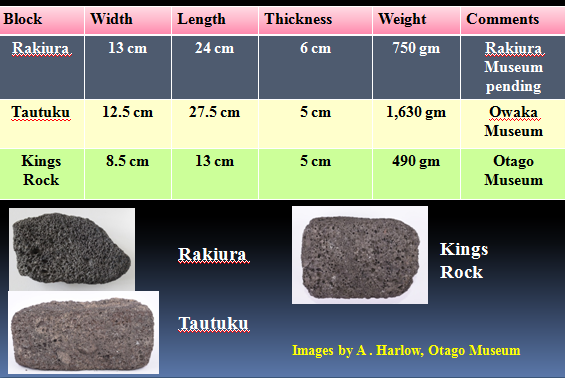
Figure 1: Dimensions, weights, and current locations of the three scoria blocks found at the Kings Rock, Tautuku, and Old Neck (Rakiura) archaeological sites in southern New Zealand. (Images by Anne Harlow, Otago Museum).
The Kings Rock (Catlins) scoria block:
In December 1937 David Teviotdale found evidence of early Māori occupation at Kings Rock. (Teviotdale, 1937-39). At this time Teviotdale was employed by the Otago Museum to collect artefacts from various South Island archaeological sites. In that same month Les Lockerbie, who was later to become an Education Officer at the Otago Museum, joined Teviotdale to assist with the excavation of a small area at the southern end of the site (Fig. 2). Lockerbie continued work at Kings Rock during 1938 then in January of 1939 both Teviotdale and Lockerbie joined to complete the original excavation (Lockerbie, 1940).
Lockerbie wrote up this joint excavation at Kings Rock and published that work (Lockerbie, 1940). Today, Kings Rock (Mahaka Point) on the Catlins coast, South Otago, is a favourite fishing spot named after a large outcrop of rock situated on the beach. At high-tide this large rock used to appear as an island, although today it has largely eroded away. The site is situated on the coast a few kilometres south of Papatowai and is only accessible by way of a well-formed Department of Conservation (DoC) track which extends south from Papatowai (Fig. 3).
The main excavation site at Kings Rock (NZAA ArchSite G47/51) is situated at the southern end of a narrow marine terrace adjacent to a sandy beach with low steep hills behind the cove (Fig. 4). The site which covers an area of about 250 m2 is well sheltered from all directions except from the east and extends from north to south for a distance of approximately 50m. It is apparent that the site has been flooded by water from a spring since occupation with much of the area today being swampy. It was on Monday 30 January 1939, while working alone, that Teviotdale found a worked block of scoria. The following is copied from Teviotdale’s diary for that day.
Monday January 30th, 1939.
Left home about 8am and arrived at Kings Rocks at 8-43 and commenced work where Les stopped. Dug there until 10am getting nothing and the water was troublesome. I got a few rough pieces of whales bone and a human femur but nothing any good. Moved to the southern edge of our work and dug there until 2pm with half an hour for lunch. The ground was about three feet deep with a layer of Maori refuse about 6 to 12 inches in depth. I got several pieces of worked moa bone and a small poor sinker and a square piece of pumice. It is very coarse and but for its lightness, looks more like scoria than pumice. (the word pumice was subsequently bracketed and the words ‘it is scoria’ were inserted). At 2pm I shifted to the other beach and dug there till 4pm getting two pieces of worked bone. One is human bone and shows the method of cutting bone into strips. Returned to the southern place and dug until 4-40pm for nothing but joined my trench to Lockerbys earlier work. Packed up about 4-40 and left at 4-45 and went home by the coast nearly an hours walk. It was a real summers day but the wind off the sea was cold and it kept the sandflies quiet. I was very tired. (Teviotdale, 1937-1939).
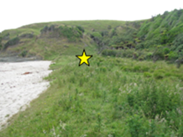
Figure 2: View looking south along low-level marine terrace at Kings Rock, Catlins. Star indicates location of the 1937-1939 Teviotdale-Lockerbie excavation site. (Image by G. Collett).
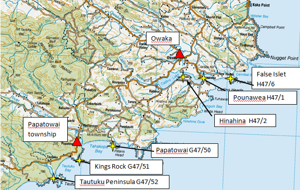
Figure 3: Locality map for the Catlins coast, South Otago, showing various archaeological sites. NZAA ArchSite numbers are shown for each locality.
From David Teviotdale’s diary (Teviotdale, 1937-39) and Lockerbie’s publication (Lockerbie, 1940), it is possible to reconstruct the stratigraphic context of the Kings Rock scoria block (Figs. 4, 5).
Figure 4: Sketch map of Kings Rock and archaeological sites. (Lockerbie, 1940). Reproduced courtesy of JPS (Lockerbie, 1940).
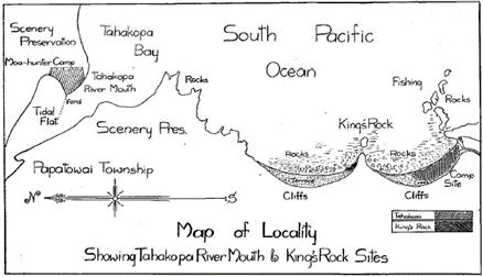
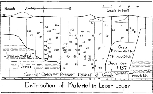
Figure 5: Sketch map of lower level excavation at Kings Rock, Catlins, 1937-1939. (Lockerbie, 1940). The area in which the scoria block was found is within the area excavated by Teviotdale shown at the bottom right corner. Reproduced courtesy of JPS (Lockerbie, 1940).
The Kings Rock scoria block is rectangular in shape, weighs 490 g and measures 8.5 cm x 13 cm x 5 cm thick (Fig. 1). Teviotdale records that the scoria block was found in a Māori ‘refuse layer’ some 6 – 12 inches thick at a depth of some 2 feet, the total thickness of the dark occupation layer and overburden being some 3 feet (Fig. 6). Artefacts associated with the scoria block included several pieces of worked moa bone and a poor sinker. In addition Teviotdale collected 64 other artefacts from the southern end of the site. These included bone fish hook points and shanks; worked moa bone tabs; bone awls; stone fishing sinkers and hammers; grind stones and polishers; stone flakes and cutters; and one basalt adze. Teviotdale also found an incomplete human skeleton in the same area.(Lockerbie, 1940 p. 420-21). Lockerbie reported that moa, whale, and seal bones were plentiful at all levels in the site; that barbed fish hook points were found in the lower layer; adzes and fish hooks were typically Polynesian; quartz was the most favoured material for hammer stones; obsidian was present; and the total absence of drill points was remarkable. (Lockerbie, 1940 p. 409).
Figure 6: Stratigraphic setting for Kings Rock scoria block, compiled from Lockerbie (1940) and diary entries by Teviotdale (1937-1939). The Teviotdale section is located some 4.6 m (15 feet) south of the east-west Lockerbie trench No. 8 (Fig. 5). Both sections go down to basal clay.
Tautuku (Catlins) scoria block:
Over 20 years later Lockerbie carried out two excavations on the Tautuku peninsula in 1956 and 1963. The site is located a few kilometres south of Kings Rock at the south end of Tautuku Bay on a large sand dune where the Tautuku River meets the sea (Fig. 7). The site is only accessible on foot or by four wheel drive vehicle south along the 3 km sandy beach. On reaching the site one has to traverse the Tautuku River which is tidal. Today the site (NZAA ArchSite G47/52) still remains much as it was when Lockerbie carried out his excavations.
Lockerbie (1970) refers to the discovery of articulated leg bones of Dinornis torosus at Tautuku during the 1956 excavation (Figs. 8, 9);
This leg (tarsus, tibia, and femur) excavated in January 1956, lay in a dark, packed occupation layer containing flake knives. The bones were identified independently by Professor B. J. Marples, Dr. R. A. Falla, and Mr R. J. Scarlett. In this case the C14 dating was: ‘Dinornis torosus’ AD 1670 ± 60 years.
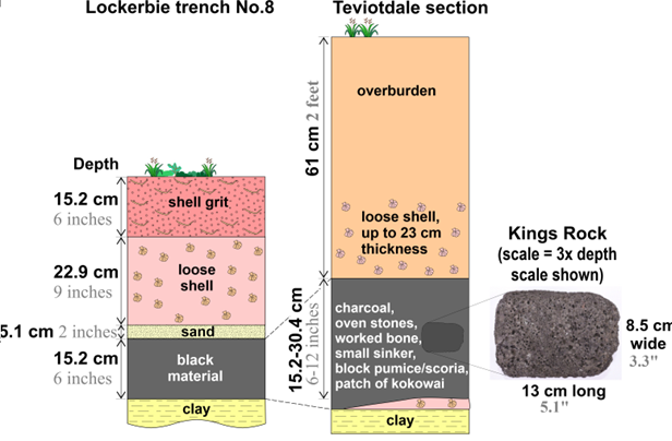
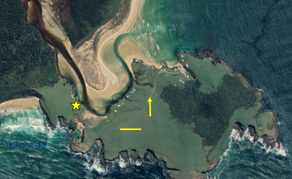
Figure 7: Aerial view of Tautuku peninsula, Catlins; yellow star indicates the location of the excavation site, horizontal bar = 100 m, arrow points north. (Image courtesy of TerraMetrics, 2020).
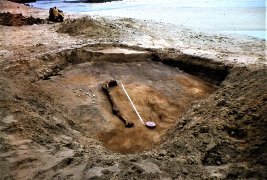
Figure 8: View looking north-west over the 1956 Tautuku excavation site with moa remains (Dinornis sp.) exposed in part within a dark occupation layer. The overlying white, wind-blown sand (drift) is reported by Lockerbie to be 6 feet thick (Fig. 9). We regard this to be an error and instead the thickness should be ~6 inches (~15.3 cm). This in turn suggests that the dark occupation unit is approximately 8 inches thick (20.3 cm) which in turn overlies yellow-orange sand. This yellow-orange sand can be seen in the foreground while moa crop stones can be seen to the left of the leg bones. Scale is a partially un-rolled tape measure. Photographed in January 1956. (no date available)
(Image courtesy Les Lockerbie Collection).
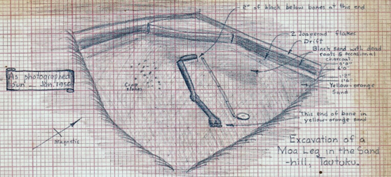
Figure 9: Field sketch by Lockerbie looking north-west over the 1956 Tautuku excavation site with moa remains (Dinornis sp.) exposed in part in a dark occupation layer that grades towards the foreground into a yellow-orange sand. Partially unrolled tape measure gives scale in feet. (Sketch courtesy of Les Lockerbie Collection).
Lockerbie asked his friend Bill Knox who owned a holiday bach/crib at Tautuku to ‘keep an eye on the site’. Seven years later on Thursday 7th November 1963 Knox discovered a shaped scoria block (Fig. 1), exposed by wind-blown sand and close to the 1956 excavation. Knox alerted Lockerbie of his ‘find’ and Lockerbie, who lived in Dunedin, reacted immediately such was his interest. Details of his excitement are recorded in his letter to Roy Trail of Stewart Island the following Wednesday, dated November 13th, 1963:
Last Friday night (10.30pm) Ernie Munro and I set off for Tautuku (South Otago). We picked up a couple of friends at Balclutha and arrived at Tautuku Beach about 3 a.m. We carried our packs along the two-mile beach and were wading the river about 3.45 a.m. We had an excellent day, and found some very interesting material, including numerous moa bones (feet, beaks, legs, etc. ) and a few artefacts. One large moa bone barbed fish hook, found in association with bones of a small species of moa, was of particular interest. What set off this sudden burst of energy was the finding by a visitor of a block of scoria (similar to one I had discovered at Kings Rock about three miles distant), in association with a hog-backed adze that had been broken and used as a hammer. The trip was most successful, and getting back home at midnight on Saturday we could really say we hadn’t wasted a minute of our time. (Lockerbie unpublished letter to Roy Trail, 13th November, 1963).
Lockerbie records in a publication, which he wrote to accompany a filmstrip for schools (Lockerbie, 1970), that the scoria block was found in the ‘Moa-hunter’ layer a few feet from the Dinornis bones and in the same occupation layer with a broken hog-backed adze (Figs. 10, 11). In that publication Lockerbie referred to the Tautuku scoria block in two quotes with special reference to ‘Moa- hunters’:
Quote: 13.
Further Excavations on Tautuku Peninsula. Excavation of the occupation layer revealed flake knives of jasperoid rock and quartzite, as well as other artefacts typical of the southern Moa-hunter.
Quote: 14.
Scoria Block found in the Moa-hunter Layer. This block of scoria was found a few feet from the Dinornis bones and in the same layer. With it was a broken hog-backed adze that had been used as a hammer. The adze, of triangular section, is a common Moa-hunter type. (Lockerbie, 1970).
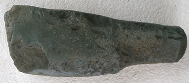
Figure 10: Image of damaged adze found in the Lockerbie photo collections. We speculate that this adze may be the one reported by Lockerbie from the 9th November 1963 excavation at Tautuku. From the image the adze looks to have been made from a fine grained volcanic or an indurated fine-grained sedimentary rock. (Image courtesy Lockerbie Collection).
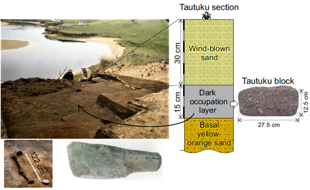
Figure 11: Stratigraphy of the 1963 Tautuku excavation and discovery of the Tautuku scoria block. (Images courtesy of Les Lockerbie Collection and Anne Harlow, Otago Museum).
The broken hog-backed adze found in the occupation layer with this scoria block has not been located in any of the collections of the Otago Museum, Balclutha Museum, or Owaka Museum. In the Lockerbie photo collection an image lacking any annotation was discovered which may be this adze (Fig 10).
Notably, Lockerbie immediately saw similarities between the Tautuku block and that recovered from Kings Rock some 27 years earlier. The Tautuku scoria block was much larger than the block from Kings Rock weighing 1.63 kg compared with 490 g. It is 27 cm in length and 13 cm in width with a gently convex top in profile. Following the discovery of this block Bill Knox gave it to Lockerbie for safe keeping. The block has now been deposited in the Owaka Museum by the Knox family on long-term loan.
The Old Neck, Rakiura (Stewart Island) scoria block:
In 2015 whilst visiting Rakiura (Stewart Island) Russell Beck was shown a third scoria block found in 1975 amongst surface midden material at the Old Neck (NZAA ArchSite E48/39) by Phillip Smith, a long-time resident of Rakiura. Beck, who was the former Director of the Southland Museum and Art Gallery, was well aware of both the Kings Rock and Tautuku blocks. When Beck saw the Rakiura block of scoria he immediately realised a link to the other blocks. In an interview with Phillip Smith in September, 2019 the lead author of this contribution (GC) recorded the following: (The full account is given in Appendix 1).
……………………………….One day I found an unusual piece of stone at the south end of the Old Neck in Paterson’s Inlet. It would have been around 1975 ……………………………………. While walking and looking I discovered the piece of stone lying exposed in the sand among scattered shells and oven stones………………………………..In or around September 2015 I met Russell Beck who had come to the island to see the Māori artefact collection at the Rakiura museum. …………………………..When I showed him the piece of stone he told me it was scoria and that it had come from a volcano. He became really excited and told me about two similar blocks that had been found on Māori sites in the Catlins. (Phillip Smith, September 2019).
John Hall-Jones records that this isthmus was once the site of an ancient Māori village, possibly the first on Rakiura (Hall-Jones, 1994).
In the early 1960s Lockerbie carried out extensive excavations at the Old Neck on Rakiura. In an article to the Otago Daily Times he records:
Excavations revealed seven strata in the ground, each representing different occupations of the land from first settlement through to European times. He observed that Māori cooking ovens were numerous, that moa bones were plentiful in the lower layers, that there were extensive deposits of fish bone, and that there were Moa Hunter type artefacts including barbed fish hooks in almost every layer. In one place a large quantity of mainly moa leg bones representing 40 birds was unearthed. In another area fourteen seal skulls were dug up. (Lockerbie, 1961).
It would appear that the scoria block discovered by Phillip Smith around 1975 had eroded from an oven area high-up on an adjacent sand dune and then it moved down the steep slope to a level area stopping some 30 m distance from the tidal shore on the western side of the tombolo – that is the Old Neck (Figs. 12, 13, and 14).
This block had been shaped and was comparable to both the Kings Rock and Tautuku blocks weighing 750 g compared with the Kings Rock block at 490 g and the Tautuku block at 1.63 kg. (Fig. 1). The colour and vesicular appearance of all three blocks are similar however part of the Rakiura block is damaged on one corner.
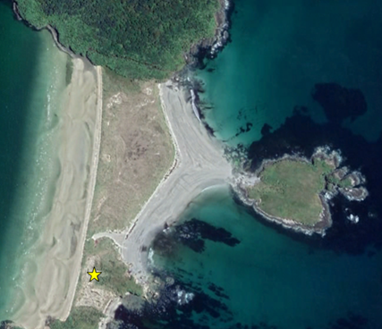
Figure 12: Aerial view of Old Neck (Rakiura); yellow star indicates the location of scoria block. Cow Island to the right (north-east) of star. Horizontal bar = 100 m, arrow points north. (Courtesy of TerraMetrics, 2020).

Figure 13: Phillip Smith standing (September 2015) approximately where he found the Rakiura scoria block at the Old Neck in 1975. View looking north. On the skyline, middle distance, can be seen the now vegetated remains of a midden location (NZAA E48/39) shown in Fig. 14 when photographed by Lockerbie in the early 1960s. (Image courtesy of Russell Beck).
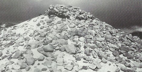
Figure 14: Exposed oven stones at the Old Neck, Rakiura. (Image by Lockerbie early 1960s).
1930 Survey of Mehetia Island by Kenneth Emory:
A key feature linking these three southern New Zealand scoria blocks is the similarity noticed by both Henry D. Skinner and Lockerbie with a collection of east Polynesian blocks held by the Otago Museum. That research commenced with an early scientific expedition to the Tuamotus and the Society Islands in 1929 – 1930. Kenneth Pike Emory (1897-1992) of the Bishop Museum, Hawaii, was instructed by the Museum to carry out a survey of the numerous atolls that comprise the Tuamotu Archipelago commencing in early 1929 and parts of the Society Islands, French Polynesia. In December 1930, Emory together with Skinner, lecturer in Anthropology at Otago University and subsequently Director of the Otago Museum, surveyed Mehetia (Meetia/Mehitea/Me’etia) Island, (Fig. 15) located some 110 kms east south-east of Tahiti in the Society Islands. It was this expedition to Mehetia that initiated a series of events leading up to the current research described here. Emory subsequently published his seminal work on stone structures in the Society Islands. (Emory, 1933).
Mehetia Island is a small, steep-sided, strato-volcanic island lying approximately 110 km east, south-east of Tahiti (17o15’32”S; 148o04’04”W). The island has an area of 2.3 km² with its highest point above sea level being 435 m. The volcanic crater is 150 m wide and 80 m deep. A narrow fertile shelf on the south-west side of the island allows for habitation and cultivation.
In the account of his visit to Mehetia, Emory (1933, p. 114) records the following;
December 13-16, 1930. I was assisted by Mr. H. D. Skinner of New Zealand, and we were accompanied by Mr. Martin L. Grant, Botanist on the staff of Bernice P. Bishop Museum, who made a botanical and geological survey of the island. The expedition was made possible through the cooperation of Mr. A. Krainer, who owned the greater part of the island. Mr. Krainer completed our party (Fig. 16).
and,
Living on Meetia at the time of our visit were two native families. Although not well acquainted with Meetia traditions, they knew the location of the marae ruins. To these they gladly guided us, besides helping in many ways to make our visit comfortable and profitable. Six maraes in a fair state of preservation, and traces of four others were seen. It is possible that other marae sites escaped notice.

Figure 15: Mehetia Island. (Image courtesy of Tahiti Heritage). https://www.tahitiheritage.pf/mehetia-enorme-volcan/
In discussing the maraes on Mehetia Emory records the following rock types that were used; coral, limestone, red tuff (from Teruahonu beach), dike prisms, black pumice (which we interpret as basaltic scoria), porous lava (vesicular lava), and compact basalt. He also records that at the Mahutoa marae the presence of many squared pieces of coral and black pumice along the front of the ahu or altar of which samples were collected (Emory, 1933, p. 119).
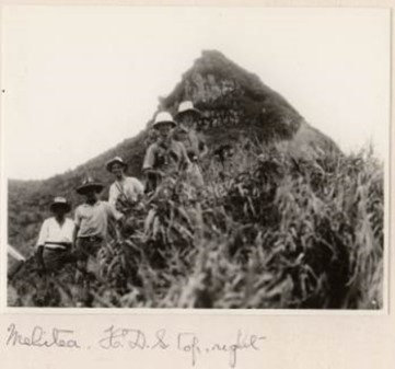
Figure 16: Photograph of Mehetia expedition 1930 showing Skinner at top right. Notice the spelling of Mehitea on the photograph. (Image from H. D. Skinner Collection).
Skinner brought back various artefacts from the Society Islands, including a number of scoria blocks (Table 1, Fig. 17) and donated them to the Otago Museum. Two of these blocks (D31.319, D31.322) are listed in the Museum’s register as dressed stone ruined marae and dressed stone marae, Tahiti. A further six blocks (D31.324 to D31.329) are either listed as stone blocks or dressed stone, marae and all from Mehetia. Three of these (D31.327, D31.328, and D31.329) have been geochemically analysed and their results are to be given in a subsequent publication now in preparation. In addition three dressed coral blocks were also deposited in the Otago Museum by Skinner.
Table 1: Otago Museum register list of shaped blocks from Society Islands deposited in 1931 by Skinner. (Courtesy Otago Museum). * Analysed for major and minor elements. # Analysed for major, minor elements, and isotopes (Ramsay et al. (2021).
Register No. | Details | Location | Dimensions (cm) | Weight (g) |
|
|
|
|
|
D31.319 | Dressed stone, ruined marae | Tahiti |
|
|
D31.322 | Dressed stone, marae | Tahiti |
|
|
D31.324 | Dressed stone, marae | Mehetia | 190x120x80 | 3445 |
D31.325 | Dressed stone, marae | Mehetia | 180x140x90 | 2835 |
D31.326 | Dressed block | Mehetia | 185x115x65 | 2195 |
D31.327 # | Dressed block | Mahetia [sic] | 60x90x130 | 590 |
D31.328 * | Dressed block | Mehetia | 50x105x112 | 310 |
D31.329 * | Dressed block | Mehetia | 70x130x190 | 1090 |
D31.330 | Dressed coral | Mehetia | 175x110x80 | 1920 |
D31.331 | Dressed coral | Mehetia |
|
|
D31.332 | Dressed coral | Mehetia |
|
|
|
|
|
|
|

Figure 17: Six scoria blocks collected by Skinner from Mehetia Island and now in the collections of the Otago Museum. (Image courtesy of A. Harlow, Otago Museum).
It was this collection of blocks that first caught the attention of Les Lockerbie who had been interested in archaeology from an early age. He eventually became one of New Zealand’s leading archaeologists of his time. It was he who recognised a possible link between these scoria blocks in the Otago Museum and the one excavated at Kings Rock in 1939. Lockerbie published the work on this excavation in 1940 and he notes:
One of the most interesting discoveries was a block of scoria which in material, shape, and size resembles dressed blocks from a marae in Mahetia, Society Islands, two of which (D.31.327 and D.31.329) are exhibited in the Otago Museum. The specimen is apparently unique in New Zealand, though Professor Benson states that there is no reason why material of similar structure should not be found in Otago. In this case the block must be classified as a polisher. (Lockerbie, 1940).
Later in the conclusions of that publication (Lockerbie, 1940, p. 409, No. 18) Lockerbie states:
The finding of a block of scoria so closely resembling the dressed Mahetia blocks is at present unique in New Zealand.
Again the block is referred to under Material secured by Mr.Teviotdale from southern end of deposit. (Lockerbie, 1940, p. 420).
No 291. ( D.39.1269). ‘Dressed stone scoria block’, with the remarks. ‘Similar to blocks from Mehetian marae.
The Otago Museum classifies this artefact in its accession register as follows:
D.39 1269 ‘Polisher of vesicular lava. Kings Rock. Papatowai’. Coll. & Pres. D. Teviotdale & L. Lockerbie.
Lockerbie had noticed that the Kings Rock block was similar in structure, shape, size, and material to the Tahitian blocks in the Museum collections and he queried as to whether the Kings Rock block had come from the same volcanic source. He wrote in his unpublished notes:
I consulted with Dr. H. D. Skinner Director of the Otago Museum who agreed that the blocks were similar. He opened the display case and removed one of the Mehetian blocks and handed it to me with the instructions that I was not to let it out of my possession and to keep it until I had solved the problem – the source of the Kings Rock specimen.
Skinner also loaned Lockerbie the Kings Rock block with the same instructions. The two blocks remained in Lockerbie’s possession until he died in 1996 at the age of 84 years. They remained with his personal collection of early Māori material from the Catlins, which is now housed in the Owaka Museum in South Otago. The two blocks (Mehetian block and Kings Rock block) that were on long term loan have since been returned to the Otago Museum.
Lockerbie had always maintained that the early canoe voyagers came directly to the Southland area of southern New Zealand from their homeland. In a report published in the Otago Daily Times (Lockerbie, 1961), he stated:
I do not hold with the theory that Polynesians definitely landed first in the North Island and gradually spread south. While this might have occurred there is as yet no evidence to support this theory and there is nothing to consider the possibility that canoes, intentionally or otherwise, could have arrived at Stewart Island as early as anywhere else.
With the subsequent discovery of the Tautuku scoria block located not far removed from the Kings Rock site, Lockerbie realised that these two finds may prove very important in the future if one or both could be sourced back to a location somewhere possibly in East Polynesia. At that time there were no reports of any similar finds elsewhere in New Zealand. Lockerbie always maintained that the people who brought these blocks probably came directly to southern New Zealand, possibly via the Chatham Islands. If this was the case then this raises the question as to why they brought these shaped blocks with them from their homeland; were they to be of some physical use, or was there some deeper spiritual meaning attached to them?
14C dates obtained from and studies of numerous localities along the Catlins coast (Fig. 1) including False Islet/Island, Pounawea, Hinahina, Papatowai (Rafter, 1955; Rafter et al., 1972; Fergusson and Rafter, 1957, 1959; Lockerbie, 1959; Lockerbie, unpublished notes; Grant-Taylor and Rafter, 1963; Hamel, 1978, 1980, 2001; Anderson, 1989; Anderson and Smith, 1992; Petchey, 1999) overall indicate an early stage for settlement in these coastal areas.
Conclusions:
Three shaped scoria blocks have been recovered from archaeological sites in the Catlins (South Otago) and Rakiura (Stewart Island). All three artefacts are clearly anthropogenic in origin. The two Catlins artefacts can be provenanced to specific occupation layers within their specific site stratigraphy. The third from Rakiura was recovered from a surface lag deposit closely associated with an extensive Māori cooking area. Under microscopic examination these blocks show no evidence of use-wear or fire damage. Volcanic scoria does not occur in South Otago and Southland and moreover visual inspection indicates that all three items are derived from fresh scoria produced from a very young volcanic eruption or eruptions, thus denying a source from either the mid-Miocene Dunedin complex or the coalescing Banks Peninsula mid-Miocene shield volcanoes. We conclude the following:
- All three sites were excavated in a formative period in New Zealand archaeology;
- blocks from two of these sites have secure locations within occupation layers;
- all three scoria blocks are unusual as to their singularity of occurrence in southern New Zealand;
- volcanic scoria, of which these blocks are made, is exotic to southern New Zealand;
- all three blocks based on visual features appear to be related one with the other; and
- these three blocks appear to be associated with early Māori activity in the area.
In a second paper (Ramsay et al., 2021) the petrography, mineralogy, major, trace, and minor element compositions of these blocks coupled with their isotopic compositions is investigated. These results will contribute to a number of questions relating to the early settlement phase of New Zealand with particular reference to Polynesian voyaging and the colonisation of the southern portion of the South Island, New Zealand.
Acknowledgements:
We acknowledge those that have gone before us in attempts to elucidate the origins of these scoria blocks. These include, but are not limited to, Les Lockerbie, Henry Skinner, David Teviotdale, Bill Knox, Phillip Smith, Professor Douglas Coombs, and others who worked with Lockerbie. Russell Beck, former Director of the Southland Museum and Art Gallery, played a pivotal role in recognising the significance of the Rakiura block and he supported this research. We acknowledge Simon Collett for his long-standing interest and support. Drs. Nick Mortimer, Simon Cox, Chris Adams of GNS gave valuable advice. Staff of the Otago Museum, who supported this project, included Moira White, Rachel Wesley, Anne Harlow, and the Māori Advisory Committee. Stephen and Frances White (nee Lockerbie) advised with background information and in the translation of articles in French. Presentations of this work prior to publication were given to members of the southern New Zealand Iwi and we thank Michael Skerrett (Waihōpi), Maureen Wylie (Waitaha), Phillip Smith (Kāti Māmoe), and Dean Whaanga (Awarua) for their interest. We acknowledge the generous financial support by the H. D. Skinner Fund administered by the Royal Society of New Zealand.
References
Anderson, A. J. 1989. Prodigious Birds, Moas and Moa-Hunting in Prehistoric New Zealand. Cambridge University Press, Cambridge.
Anderson, A., Smith, I. 1992. The Papatowai Site : New Evidence and Interpretations. Journal of the Polynesian Society , 101: 129.
Emory, K. P. 1933. Stone Remains in the Society Islands. Bernice P. Bishop Museum, Bulletin, 116.
Fergusson, G. J., & Rafter T. A. 1957. New Zealand 14C age measurements – III. New Zealand Journal of Science and Technology, B38: 732-749.
Fergusson, G. J., & Rafter, T. A. 1959. New Zealand 14C age measurements – IV. New Zealand Journal of Geology and Geophysics, 2: 208-241.
Grant-Taylor, T. L., & Rafter, A. 1963. New Zealand natural radiocarbon measurements 1-V. Radiocarbon, 5: 118-162.
Hall-Jones, J. 1994. Stewart Island Explored. Craig Printing Co. Ltd. Invercargill, New Zealand.
Hamel, G. E. 1978. Radiocarbon dates from the Moa-hunter site of Papatowai, Otago, New Zealand. New Zealand Archaeological Association Newsletter, 21: 53-54.
Hamel, G. E. 1980. Pounawea: The last excavation. Report the Historic Places Trust, Otago Museum.
Hamel, G. E. 2001. The Archaeology of Otago. Department of Conservation, Wellington.
Lockerbie, L. 1940. Excavations at Kings Rock, Otago, with a discussion of the fish-hook barb as an ancient feature of Polynesian culture. Journal Polynesian Society, 49: 393-446.
Lockerbie, L. 1959. From Moa-hunter to classic Maori in southern New Zealand. In J. D. Freeman & W. R. Geddes (Eds), Anthropology in the South Seas, Essays presented to H. D. Skinner, pp. 75-110. Thomas Avery & Sons, New Plymouth, New Zealand.
Lockerbie, L. 1961. Proof of early occupation, Expedition Studies. Otago Daily Times, 20 March 1961.
Lockerbie, L. 1962. Unpublished notes.
Lockerbie, L. 1963. Letter to Roy Trail, Stewart Island, 13th November, 1963.
Lockerbie, L.1970. Archaeology in Southern New Zealand Maori: The Moa-Hunter. NZ Dept Education Services 70/353, filmstrip with notes.
Petchey, F. J. 1999. New Zealand bone dating revisited: A radiocarbon discard protocol for bone. New Zealand Journal of Archaeology, 19: 81-124.
Rafter, T. A. 1955. 14C variations in nature and the effect on radiocarbon dating. New Zealand Journal of Science and Technology, B37: 20-38.
Rafter, T. A., Jansen, H. S., Lockerbie, L., & Trotter, M. M. 1972. New Zealand radiocarbon reference standards. In T. A. Rafter, & T. Grant-Taylor (Eds), Proceedings of the 8th International Conference on Radiocarbon Dating, 2: 625-675. The Royal Society of New Zealand, Wellington, New Zealand.
Ramsay, W. R. H., Collett, G. S., Ramsay E. G., & Kerby, G. 2021. Three scoria blocks from Maori occupation sites, New Zealand: Their petrography, mineralogy, geochemistry and attribution to a source locality in eastern Polynesia. Geoarchaeology, 2021: 1-19.
Smith, P. 2019. Personal verbal account to Graeme Collett. September 2019.
Teviotdale, D. 1937-1939. Personal diaries held by Hocken Library, University of Otago, Dunedin Ref. MS-0500/003.
Teviotdale, D. 1938. Final Report on the Excavation of a Moa-Hunter camp at the mouth of the Tahakopa river. Journal of the Polynesian Society, 47: 116.
Appendix 1:
Verbal account by Phillip Smith of Rakiura of the discovery of the Rakiura scoria block at Old Neck, Stewart Island in 1975 as dictated to Graeme Collett, September 2019.
I was born in 1943 and have lived on Stewart Island all my life. My ancestry is Kati Mamoe. My occupation is fisherman however in later years I was a tour operator. When I was young my father used to take me to various places on the island where Māori midden was exposed. Since then I have continued to visit these sites to check on wind and water erosion. I have never dug on a site but simply fossicked over the exposed midden. Unfortunately as time goes by many of these coastal sites, especially those facing the prevailing winds, have now disappeared. Over the years I have found many interesting artefacts. My father would tell me to bury what I found on the site and this I did. I can remember one day finding two large adzes at the Old Neck. They were in the first stage of manufacture. I buried them in the sand at the base of a large sand dune. No doubt they will still be there. I soon decided that it was more important to keep my finds and that they be displayed for everyone to see. One day I found an unusual piece of stone at the south end of the Old Neck in Paterson’s Inlet. It would have been around 1975. Being a keen deer hunter I used to visit this sandy area regularly because it was a good place to see whether deer were coming down from the bush edge to feed on the grass growing on Cow Island. Their hoof tracks were always obvious in the sand. At low tide you can walk out onto the island. While walking and looking I discovered the piece of stone lying exposed in the sand among scattered shells and oven stones. I originally thought that because of its unusual shape and colour that it may have been a meteorite so I took it home and put it in our garden. In or around September 2015 I met Russell Beck who had come to the island to see the Māori artefact collection at the Rakiura museum. In talking to him I mentioned that I had some interesting rocks at my home. Being a geologist Russell was immediately interested so he arranged to visit. When I showed him the piece of stone he told me it was scoria and that it had come from a volcano. He became really excited and told me about two similar blocks that had been found on Māori sites in the Catlins.
(Phillip Smith, September 2019).